


SityTrail - CAMPORELLS EN BEYS

UDGI54
User

Length
29 km

Max alt
315 m

Uphill gradient
471 m
Km-Effort
35 km

Min alt
196 m

Downhill gradient
472 m
Boucle
Yes
Creation date :
2019-08-17 16:48:42.337
Updated on :
2019-08-17 16:49:49.114
7h38
Difficulty : Very difficult

FREE GPS app for hiking
 SityTrail
IGN / Geographical institutes
SityTrail Plus
The world is yours!
About
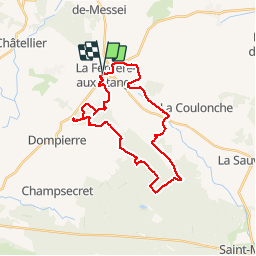
Trail Walking of 29 km to be discovered at Normandy, Orne, La Ferrière-aux-Étangs. This trail is proposed by UDGI54.
Positioning
Country:
France
Region :
Normandy
Department/Province :
Orne
Municipality :
La Ferrière-aux-Étangs
Location:
Unknown
Start:(Dec)
Start:(UTM)
682616 ; 5392940 (30U) N.
Comments